Establishing a new settlement outpost on the lands of the town of Kafr ad-Dik / Salfit Governorate
- Violation: the establishment of a new settlement outpost.
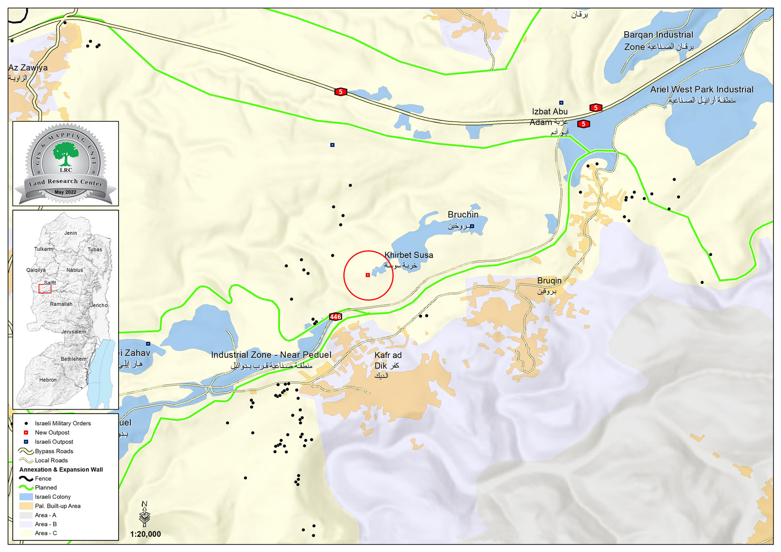
- Location: Kafr ad-Dik, west of Salfit.
- Date of violation: 04/04/2022.
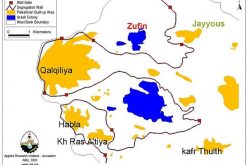
- The aggressor: the “Brukhin” settlement.
- Affected party: a number of farmers from the town.
- Details of the violation:
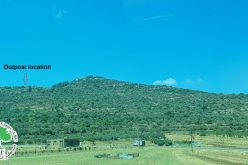
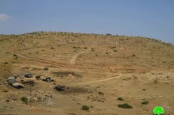
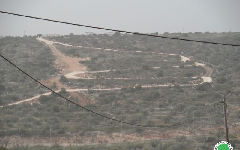
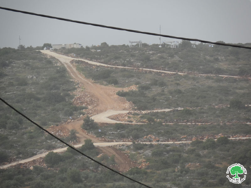
On Monday morning (4/4/2022 AD), an extremist group of colonists razed agricultural plots with the aim of establishing a new colonial outpost located in the northeastern side of the lands of the town of Kafr ad-Dik, west of the city of Salfit.
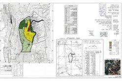
With darkness falling, a group of settlers, and through three private bulldozers which were accompanying them, began the process of building roads between the olive fields in the “Al-Maqwarat” area, located in the northeastern side of the town, adjacent to the “Brukhin” settlement from the western side. The Israeli occupation army built more than 200 meters of longitudinal roads that completely circumvent more than 32 dunums there, in conjunction with the settlement work of the land that reached 5 dunums of it, before placing two containers in it and a number of arbours in preparation for the establishment and announcement of that settlement outpost on the land.
It is noteworthy that the land that was targeted is agricultural land owned by the Palestinian family, as it is considered one of the areas that the occupation army had previously declared a closed military area, according to which access to that area is prohibited except after obtaining prior coordination, which weakened the farmers’ opportunity to take care of the it.

Human rights activist Fares Al-Deek told the field researcher of the land Research Center the following:
“The town of Kafr ad-Dik is considered one of the most Palestinian communities in the Salfit governorate targeted by the Israeli occupation, where the occupation imposed strict restrictions preventing farmers from benefiting from the lands located north and west of the town, as the town’s lands there are completely threatened by the accelerated Judaization that swallows up the town’s lands day after day. A day when there were four settlements there, and the occupation policy contributed to flooding those sites with settlements and the bypass roads that connect the them there”.
He added:
“Since the beginning of this year, dozens of olive groves have been uprooted and many settlement roads have been opened, in conjunction with the dangers and demolition of a number of agricultural rooms and the attacks on farmers. Eventually, it is about controlling the entire lands of the town on the northern and western side, which is estimated at 3,000 dunams”.
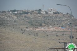
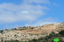
It is noteworthy that the field researcher monitored later during the current month of April that the settlers have established another settlement outpost in the west of the town near the settlement of “Pedu’el”, and this paves the way for flooding the area with settlement gatherings and Judaizing the entire area.
About the town of Kafr ad-Dik[1]:
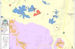
The town of Kafr ad-Dik is located 15 km to the west of the city of Salfit. It is bordered to the north by Bidya, to the west by the villages of Rafat, Deir Ballut, to the east by the villages of Burqin and Sarta, and to the south by the villages of Bani Zaid. Its population reached 5551 people until 2017, and its total area is 15529 dunums, of which 791 dunums are the building up area of the village.
The occupation confiscated an area of 2477 dunums of its lands, as follows:
- The settlements plundered 1225 dunums of village lands, which are:
|
Name of the settlement |
Year of establishment/ dunum |
Size of the confiscated land |
Number of settlers |
|
Har Alei Zahav |
1983 |
134 |
NA |
|
Alei Zahav- Yo’ezer |
1982 |
290 |
424 |
|
Pedu’el |
1984 |
800 |
1088 |
|
Bruchin |
1999 |
1 |
NA |
|
Total |
|
1225 |
1512 |
- Bypass roads plundered 362 dunums.
- The separation wall was plundered under its track of 890 dunums, and about 8842 dunums will be isolated behind it. Its length on the village lands is 8905 meters.
According to the Oslo agreement, the lands of Kafr ad-Dik are classified as B, which constitutes 15% of the area of the village, while areas C, i.e. is under the full control of the Israeli occupation, constitute 85%.
- Areas classified as “B” 2252 dunums.
- Areas classified as “C” are 13,277 dunums.
Building Israeli settlements on West Bank lands is a flagrant violation of international norms, laws and charters, the most prominent of which are:
- The Roadmap Agreement signed between the Israelis and the Palestinians on April 30, 2003: (under the auspices of the United States of America, the European Union, Russia, and the United Nations), in which the government of Israel called for a freeze on all construction in the settlements: “The government of Israel must act Immediately upon dismantling all settlement outposts erected since March 2001, in accordance with the Mitchell Report, and the Israeli government must freeze all construction activities for settlements, including natural growth. As approved plan issued by USCR 1515-2003”.
- Fourth Geneva Convention of 1949, Article No. 174: “The destruction and appropriation of property is prohibited on a large scale, not justified by urgent military necessity, and carried out unlawfully, illegally and arbitrarily”.
- The Oslo Agreement of 1995 Article No. 31 states that “it is forbidden for the Israeli and Palestinian sides to build or plan to build any settlement or settlement expansion or any other project that would change the status quo in the West Bank and Gaza Strip, and it is also prohibited for any party to take a unilateral step that would change the status quo in the West Bank and Gaza Strip”.
- Security Council Resolution No. 465 (1980), “demanding that Israel stop settlements and refrain from building new settlements and dismantling those established and also called on member states not to assist Israel in building settlements”.
- Security Council Resolution No. 446 of 1979 “called on Israel to cancel its previous measures and to refrain from taking any action that would lead to a change in the legal status and geographical character or materially affect the demographic composition of the Arab territories occupied since 1967, in particular (Jerusalem), and not to transfer its civilian population”.
- Security Council Resolution No. 452 (1979), which “calls on the Israeli government and people as soon as possible to stop the construction, construction and planning of settlements in the Arab territories occupied since 1967, including Jerusalem”.
[1] GIS – LRC
The Land Research Center
LRC