More than 1500 Dunums to be appropriated under “State Land” Pretext in the Jordan Valley
On the 20th of January 2016, the Israeli Army Radio reported that the Israeli Minister of Defense Moshe Ya'alon, is about to approve the expropriation of 1,545 dunums of Palestinian lands north of the settlement of Almog as “State Land”.
The Israeli Civil Administration; one of the Israeli Defense Ministry’ arms, and (after an alleged procedures and measures) carried out by what is so-called “Blue Line Team” in the Civil Administration, decided to declare the targeted land (about 1545 dunums) as “State land”, while, where the targeted land used by the Israeli settlers for agriculture matters for several years ago.
Moreover, and according to the Israeli Radio , part of the targeted lands had been captured to over the past 20 years by Jewish settlers of the illegal settlement of Almog (est. 1977 on an area of 486 dunums, pop 170) located south of Jericho Governorate in the Jordan Valley area.
The Israeli sources indicated also that the confiscation intention was ratified by the political echelon of the Israeli government and will soon be finalized, following a thorough examination of the land by alleged experts in the Blue line team in the field in the coming weeks.
Remarking on the Israeli new proposed colonial step , the spokesperson of what is so called the Coordination of Government Activity in the Territories (COGAT) added that :, "in conjunction with the decision made by the political echelon of Israel, and experts in the field, these lands were permitted to be announced as state owned land, and are currently undergoing the final steps in that process.”
It is worth pointed that the “Blue Line Team” is a crew in the Israeli Civil Administration related to the Israeli Ministry of Defense. The sole scope of work of the team is to check the status of the Palestinian lands and to classify them if they are located within the “state land” zone or not. If the checked lands were classified and fall within “State Land” area, the blue line team inform the related authorities with results to push them toward expropriating the land.
Largest “State Land Declaration” Since the year 2014
As a matter of fact, the Israeli new colonial step to expropriate and capture more Palestinian lands came as the largest confiscation since the Israeli Authorities declared about 4,000 dunums as state land in Bethlehem Governorate in the year 2014. To learn more about the 4000 dunums declaration, refer to the previously written case study “ The silent Israelization of the Occupied West Bank Territory.. Israel to Seize 3799 dunums of Bethlehem and Hebron Governorates Land”[1]
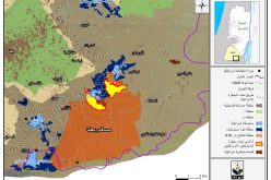
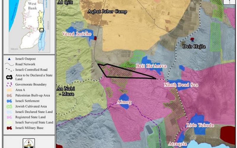
A geopolitical analyses conducted by the Geo-informatics department at the Applied Research Institute- Jerusalem (ARIJ), showed that the total targeted land area reaches to 1545 dunums and located north of the Israeli settlement of “Almog” and southwest of the Israeli settlement of “Beit Ha’Arava”, to the south of Jericho Governorate. See map 1 below:
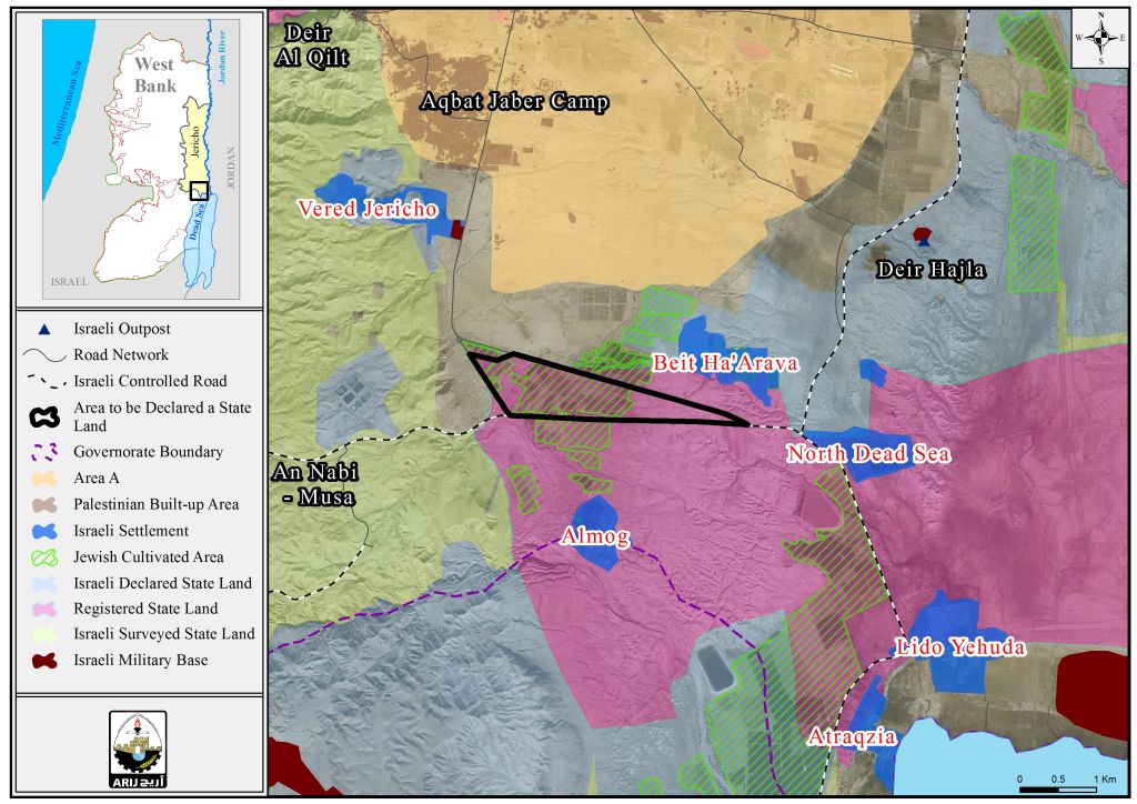
Map 1 : the lands slated to be declared as “State land”
Furthermore, the land slated to be expropriated lies within the area classified by the Israeli Authorities after the year 1967 as “Eastern Segregation Zone”, which it occupied 28% of the total area of the West Bank (1580 km2).
It is important to mention, that the targeted land used to be classified by the Israeli Authorities as “Registered State land”, while the step now is to change the status of the land to be formally “declared state land” in an alleged intention to legalize the expropriation step, while on the other hand to grant the Israeli settlers from the nearby illegal settlements a formal green light to work , build and expand on these Palestinian lands freely and without any impediments.
In point of fact , the targeted 1545 dunums are located in an area that ,illegally, classified by the Israeli Occupation Authorities as “Jewish Agriculture Area” which occupy about 103,000 dunums (1.8% from total West Bank area) .
The “State land Declaration”…an Israeli fraud to Swallow more Palestinian Lands
When Israel occupied the West Bank in 1967, only one third of the occupied West Bank territory was registered to the people with a Turkish (Ottoman Empire) issued Tabo (certificate of ownership) and/ or with an official British certificate/ registration issued during the British Mandate era. Fundamentally, the Ottoman land code (law) of 1858 continue to govern the land holdings in the West Bank but was never so used during the centuries of Ottoman rule, or under the British and Jordanian rules who maintained the same law. Israeli Military Order #59 (1967(amended by M.O.1091)), which constituted an abuse of the Ottoman land law, by which the Israeli Military-appointed position of 'Custodian of Government Property' expropriated land owned by the Jordanian Government. Also, allows the 'Custodian of Government Property' to expropriate land from individuals or groups by declaring it 'Public Land' or 'State Land', the latter which it defines as land that was owned or managed by, or had a partner who was an enemy body or citizen of an enemy country during the 1967 war.
Accordingly, when Israel occupied the West Bank territory it assumed control of what was assigned as State Land at the time – during the Jordanian Administration period; an area of 634,920 dunums (11.2% from the total West Bank area) classified as “Registered State Lands”, where according to the Israeli equivocal interpretation to the laws, Israel consider itself the legitimate heir of the Jordanian, the British Mandate, the Ottoman; respectively State Land after its military occupation to the Palestinian territory in June 1967, which is absolutely erroneous.
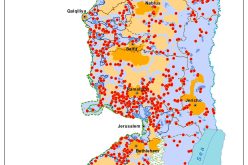
Following the Israeli occupation of the West Bank in 1967, Israel proceeded to classify an additional “Declared State Land” area of 843,922 dunums (14.9% from the total West Bank area) the high point of which was after the year 1979. Currently, the ICA prepares to complete procedures on what is called “Surveyed State Lands” which constitutes 11.7% from the West Bank with a total area of 666,327 dunums. In compilation, the total area of what classify State Land according to Israel as a “State Lands” rounds up to 2,145,169 dunums; some 38% of the West Bank total area).
It is worth mentioning that 248,904 dunums (4.4% of the West Bank area) and 11.6% of what constitutes state land according to Israel is actually located within what classifies as areas “A” and “B” according to Oslo II Interim Agreement signed between Israel and the Palestinian Liberation of Palestine (PLO), mainly in Hebron Governorate at the southern part of the West Bank. See map 2 below:
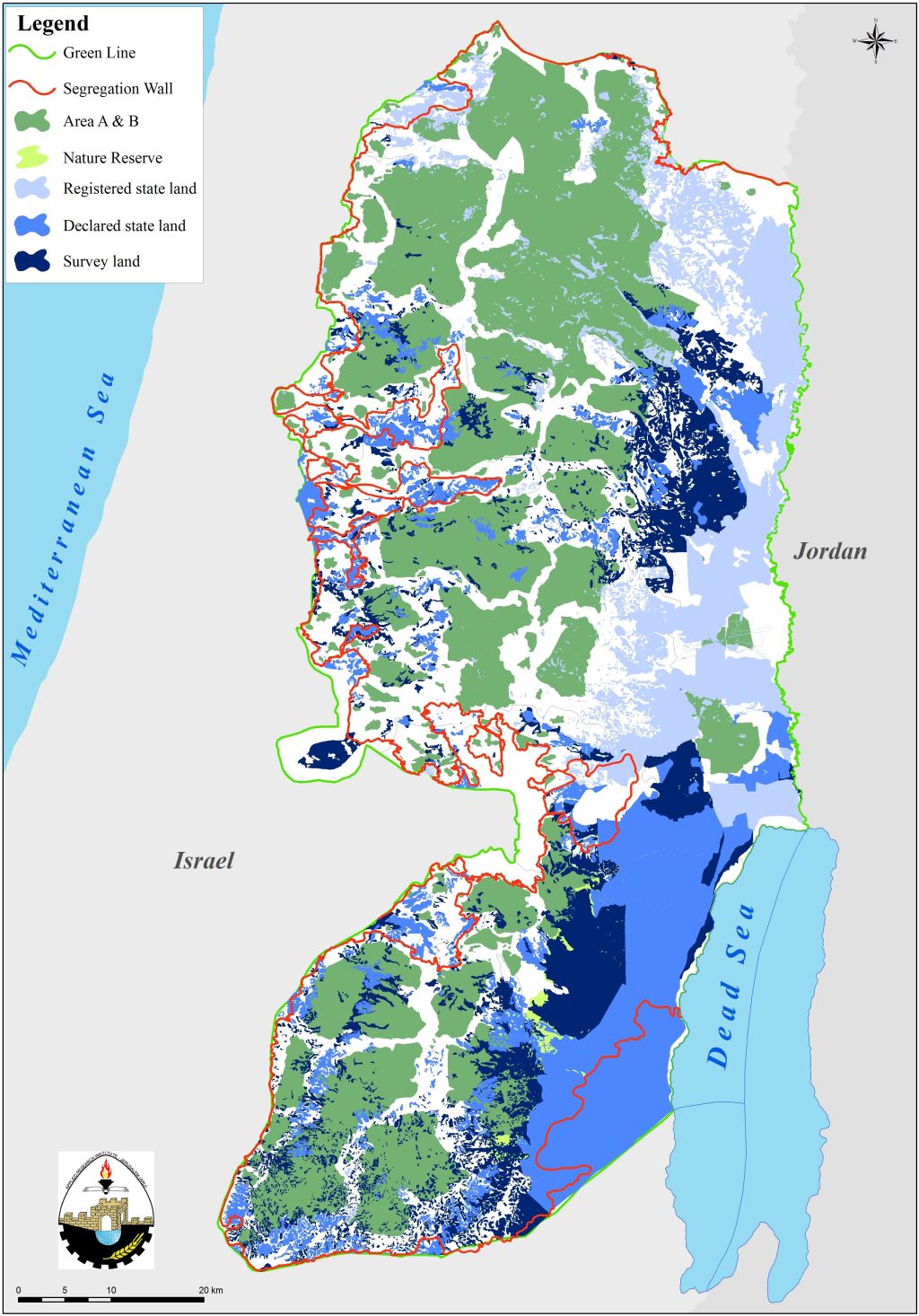
Map 2 : “State Land” areas in the West Bank according to the Israeli classification
Conclusion
The Israeli seizing of the Palestinian lands under any of claimed Israeli is a methodic Israeli circumvent over the international law rules and international legitimacy resolutions, where all of the confiscation orders issued by Israel are illegitimate and contradicts with the United Nation Security council Resolutions 242 and 338 that stipulate the illegality of the Israeli military occupation of the Palestinian lands and that includes all the confiscations, building illegal settlements and outposts and bypass roads, constructing the Segregation Wall, destroying Palestinian properties and restricting their movement and all of the colonial practices conducted by Israel since June 4, 1967-present are illegal, null and void.
The Israeli expropriation of the Palestinian lands constitute a flagrant and grave breach for the International law rules and conventions (Art. 51 of the 1949 Geneva Convention II –Art. 147 of the 1949 Geneva Convention IV- Art. 53 of the 1949 Geneva Convention IV-Art. 23(g) of the 1899 Hague Regulations – the Universal Declaration of Human Rights Adopted and proclaimed by General Assembly resolution 217 A (III) of, December 10, 1948, Articles 13 and 17 and Article 12 of the International Covenant on Civil and Political Rights, adopted by the General Assembly of the United Nations on 19 December 1966 :-
Articles 147 of the Fourth Geneva Convention indicated that: Extensive destruction and appropriation of property not justified by military necessity and carried out unlawfully and wantonly. is a grave breach of the Convention.
Art. 23 of the Hague Convention of 1907 also provides: In addition to the prohibitions provided by special Conventions, it is especially forbidden to destroy or seize the enemy's property, unless such destruction or seizure be imperatively demanded by the necessities of war;.
Article 53 of the same convention provides that 'any destruction by the Occupying power of real or personal property belonging individually or collectively to private persons, or to the State, or other public authorities or social or cooperative organizations is prohibited, except where such destruction is rendered absolutely necessary by military operations.'
Article 147 of the convention considers 'extensive destruction and appropriate of property, not justified by military necessity and carried out unlawfully and wantonly' as a grave breach of the Convention and thus constitute a war crime.
Under the Universal Declaration of Human Rights Adopted and proclaimed by General Assembly resolution 217 A (III) of, December 10, 1948, Article 17 reads: 'No one shall be arbitrarily deprived of his property.' Which means it bans Israel from destroying or confiscating the property of the Palestinians at any case.
Universal Declaration of Human Rights Article 13: Everyone has the right to freedom of movement and residence within the borders of each State.
Article 12' of the International Covenant on Civil and Political Right International Covenant on Civil and Political Rights. Adopted by the General Assembly of the United Nations on 19 December 1966: Everyone lawfully within the territory of a State shall, within that territory, have the right to liberty of movement and freedom to choose his residence.
[1] http://www.old.poica.org/details.php?Article=6886
Prepared by:
The Applied Research Institute – Jerusalem