In light of the ongoing situation in the occupied West Bank, it doesn’t seem that Israel is controlling its addiction to land appropriation and settlement expansion in the territory. On the 5th of April 2016, the Israeli human rights group Yesh-Din reported that Israel is moving towards the transformation of Ma’ale Mikhmas settlement east of Ramallah Governorate and the area around, including the settlements of Rimmunim, Pesagot and Kochav Hashahar, into a huge and contiguous settlement bloc that will see the expropriation and annexation of more Palestinian land in Ramallah Governorate, in addition to the legalization of the Mitzpe Danny outpost east of Ma’ale Mikhmas settlement.
The plan is being initiated by AMANA, an Israeli settlement movement that illegally works for the development of Israeli settlements in the occupied West Bank, and promoted by the so-called “Mateh Benyamin” regional council[1] and with the support of the Israeli defense Ministry.
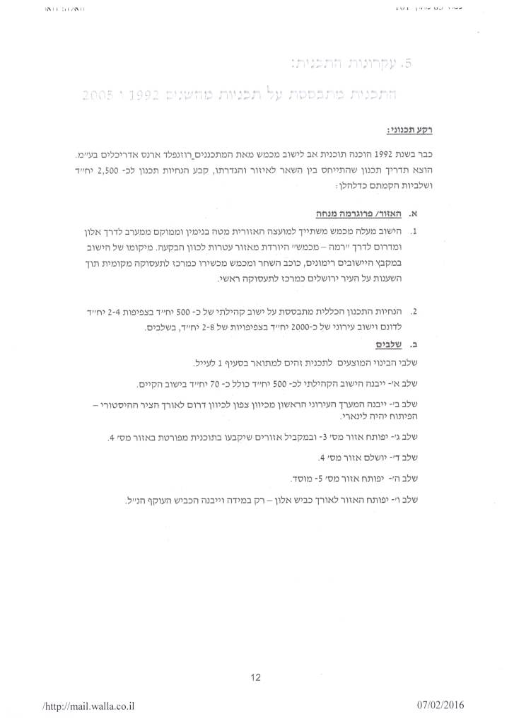
The plan, which holds number 225/3, states the appropriation of 749 dunums of Palestinian land to the east of Ma’ale Mikhmas for settlement building over the next 25 years, in addition to expanding the settlements of Remmunim, Pesagot and Kochav Hashahar. Table 1 below shows hundreds of housing units to be built in each of the aforementioned settlements by the year 2040, which will severely harm the geographical contiguity of the Palestinian communities in the area and will deny Palestinians their right to use the only available land left for them to expand and develop in the future. See Table 1 and Map 1
|
Table 1: Details of Plan No. 225/3 |
|||||||
|
No. |
Settlement Name |
Units required by 2030 |
Units required by 2040 |
Land Reserve (Dunums) |
Israeli TPS No. |
Area (Dunums) |
Population (2014) |
|
1 |
Ma’ale Mikhmas |
494 |
886 |
524 |
225, 225/1/1 |
1274 |
1400 |
|
2 |
Mitzpe Danny |
106 |
189 |
225 |
—— |
—– |
300 |
|
3 |
Rimmunim |
386 |
692 |
—– |
224/1 |
2969 |
833 |
|
4 |
Kochav Hashahar |
761 |
1363 |
——- |
223/1 |
2466 |
1881 |
|
5 |
Pesagot |
470 |
843 |
—— |
222 |
316 |
1904 |
|
|
Total |
2217 |
3973 |
749 |
——- |
7025 |
6318 |
|
Yesh-Din , Plan No. 225/3 |
|||||||
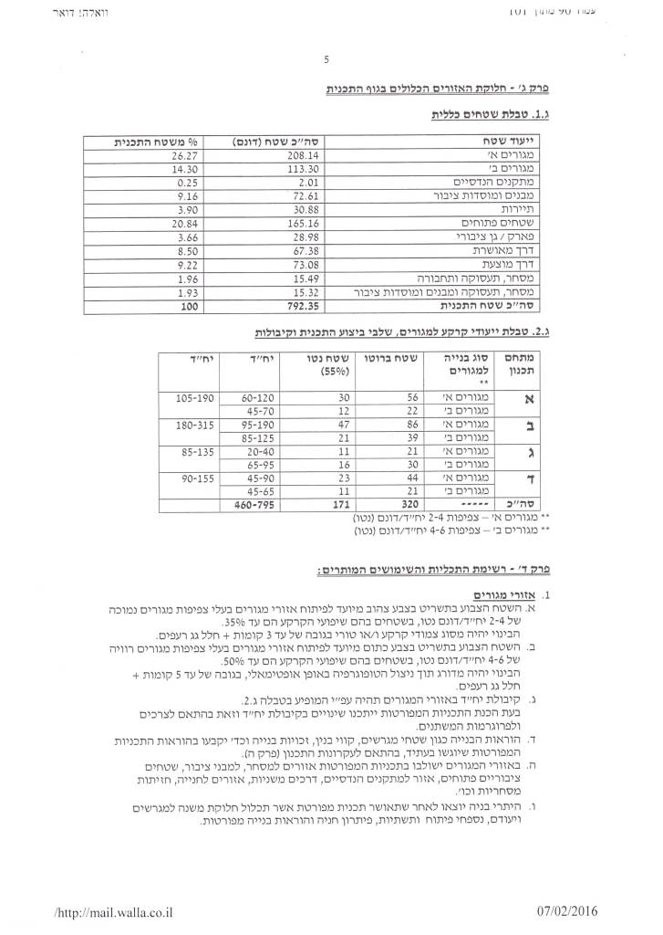


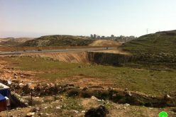
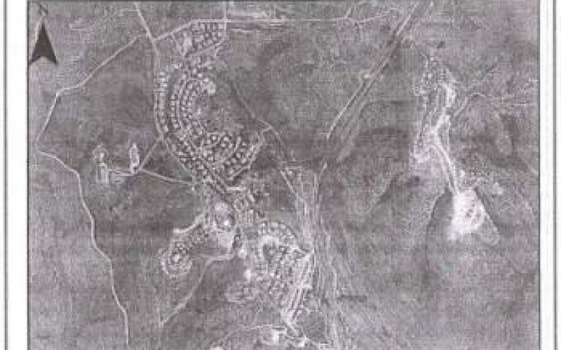
Photos 1-5: Details of Plan No. 225/3
Source: yesh-din
The four settlements along with Mitzpe Danny settlement outpost are under the jurisdiction of what Israel classifies as “Mateh Benyamin” regional council[2] which includes 14 illegal outposts[3] and 28 Israeli settlements. At the present time, this regional council has more than 60,000 Israeli settlers.
The four settlements combined, have a total population of 6318 settlers (ARIJ, 2014) and already occupy a total land area of 7025 dunums of Palestinian land. See Table 2
|
Table 2: Settlements and outposts affiliated to Mateh Binyamin Regional Council |
|||||
|
No. |
Name of Settlement/outpost |
Type |
Pop. (2014) |
Governorate |
Area (Dunums) |
|
1 |
Niriya |
Outpost |
—- |
Ramallah – Near Talmon |
—- |
|
2 |
Ahiya |
Outpost |
130 |
Nablus |
—- |
|
3 |
Esh Kodesh |
Outpost |
80 |
Nablus |
—- |
|
4 |
Givat Haorel |
Outpost |
180 |
Ramallah |
—- |
|
5 |
Zayt Ra'nan |
Outpost |
130 |
Ramallah |
—- |
|
6 |
Harsha |
Outpost |
200 |
Ramallah |
—- |
|
7 |
Migron |
Outpost |
250 |
Ramallah |
—- |
|
8 |
Mitzpe Kramim |
Outpost |
180 |
Ramallah |
—- |
|
9 |
Mitzpe Hagit |
Outpost |
50 |
Jerusalem |
—- |
|
10 |
Neve Erez |
Outpost |
45 |
Ramallah – Near Maale Mikhmas |
—- |
|
11 |
Mitzpe Dany |
Outpost |
300 |
Ramallah |
—- |
|
12 |
Adi Ad |
Outpost |
150 |
Ramallah |
—- |
|
13 |
Amona |
Outpost |
250 |
Ramallah |
—- |
|
14 |
Tel Zion |
Outpost |
NA |
Ramallah – Near Kochav Yacov – West |
—- |
|
15 |
Shilo |
Settlement |
2948 |
Nablus |
1613 |
|
16 |
Shevut Rahel |
Settlement |
694 |
Nablus |
1229 |
|
17 |
Remunim |
Settlement |
833 |
Ramallah |
2696 |
|
18 |
Pesagot |
Settlement |
1904 |
Ramallah |
316 |
|
19 |
Ofra |
Settlement |
3552 |
Ramallah |
731 |
|
20 |
Anatot |
Settlement |
1214 |
Jerusalem |
846 |
|
21 |
Eli |
Settlement |
3827 |
Nablus |
3318 |
|
22 |
Ateret |
Settlement |
996 |
Ramallah |
639 |
|
23 |
Naale |
Settlement |
1441 |
Ramallah |
704 |
|
24 |
Nili |
Settlement |
1276 |
Ramallah |
368 |
|
25 |
Nahliel |
Settlement |
548 |
Ramallah |
2340 |
|
26 |
Nofei Prat |
Settlement |
1241 |
Jerusalem |
886 |
|
27 |
Adam (Geva Benyamin |
Settlement |
5065 |
Ramallah |
1213 |
|
28 |
Alon |
Settlement |
937 |
Jerusalem |
312 |
|
29 |
Maale Levona |
Settlement |
793 |
Ramallah |
1317 |
|
30 |
Beit Horon |
Settlement |
1218 |
Ramallah |
720 |
|
31 |
Givon Hadasha |
Settlement |
1239 |
Jerusalem |
370 |
|
32 |
Maale Mikhmas |
Settlement |
1400 |
Ramallah |
1274 |
|
33 |
Dolev |
Settlement |
1310 |
Ramallah |
996 |
|
34 |
Mattityahu |
Settlement |
1538 |
Ramallah |
446 |
|
35 |
Neve Tzuf (Halamish) |
Settlement |
1282 |
Ramallah |
674 |
|
36 |
Hashmonaim |
Settlement |
2880 |
Ramallah |
1079 |
|
37 |
Talmon |
Settlement |
3486 |
Ramallah |
1901 |
|
38 |
Kochav Hashahar |
Settlement |
1881 |
Ramallah |
1644 |
|
39 |
Kochav Yacov |
Settlement |
6993 |
Jerusalem |
2466 |
|
40 |
Kfar Adumim |
Settlement |
3919 |
Jerusalem |
1005 |
|
41 |
Mevo Horon |
Settlement |
2425 |
Ramallah |
880 |
|
42 |
Mitzpe Yericho |
Settlement |
2270 |
Jericho |
1174 |
|
|
Total |
|
61055 |
|
33157 |
|
Yesha Regional Council website , 2015 |
|||||
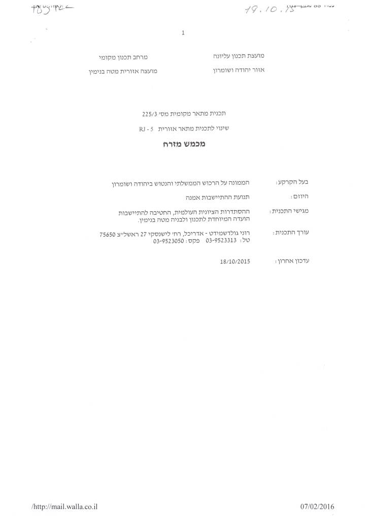
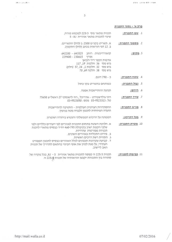
The implementation of Plan No. 225/3 on the ground will foresee an increase in the population of the aforementioned settlements, which ultimately will increase the population of the so-classified “Mateh Benyamin” regional council over the next 25 by 77,000 Israeli settlers, as stated. See Copies of the plan
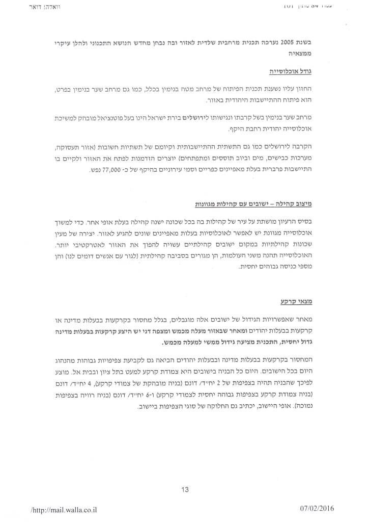
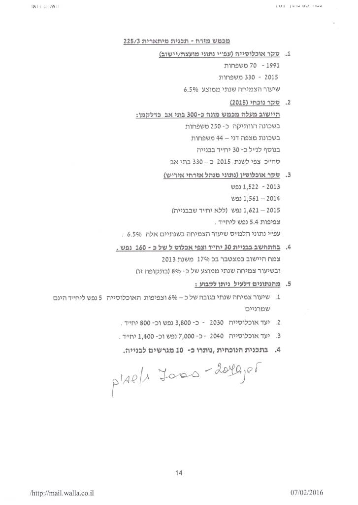
Photos 6-8: expected population in the aforementioned settlements by the year 2040
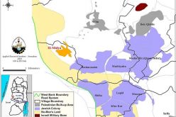
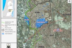
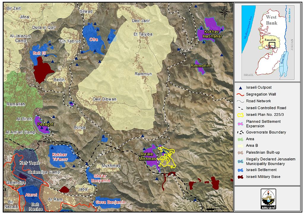
Analysis of the plan No. 225/3 also showed that the targeted 749 dunums of Palestinian land is classified as “Registered State Land”. This is the land Israel assumed control of following its occupation of the Palestinian territory back in 1967, of what was assigned as “State Land” during the Jordanian Administration period[4]; See Map 1

Map 1: Plan of Ma'ale Mikhmas East 225/3
Another impediment to the geographical contiguity of the Palestinian communities
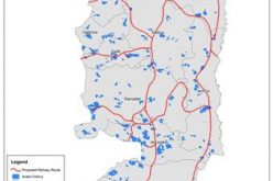
Since Israel started the construction of the Segregation Wall in the occupied West Bank in June 2002, it claimed that the wall will defend its citizens against terror activities[5]. However, Israel has used the Segregation Wall as a political tool to grab as much Palestinian land as possible and exercise more control over the Palestinian territory in an attempt to sustain the future of its settlements in the occupied Palestinian territory. So far, Israel has completed the construction of more than 60% of the wall in the occupied Palestinian territory and upon its completion, it will guarantee the annexation of 107 Israeli settlements (out of 196 total in the oWB) and 60 outposts to Israel’s unilateral and illegal border.
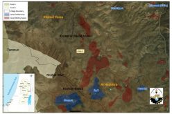
However, the plan of the Israeli Segregation wall did not meet the needs and aspirations of Israel's settlement project in the oPt because many Israeli settlements that are of strategic, geographic and religious importance have remained outside the wall route plan (on the eastern side of the wall), and Israel has not included them in any future colonial plan. This is the case of Ma’ale Mikhmas and the neighboring settlements, Pesagot, Rimunim and Kochav Hashahar, which form a new and a very strategic settlement gathering in the area, were not among the list of settlements Israel plans to annex to its illegal border through the construction of the wall. However, plan No. 225/3 meets the ambitions of the Israeli Government because it will enable the appropriation of more Palestinian land in the area and reserve it for future settlement building and expansion. Additionally, the building planned in the aforementioned settlements will form a territorial contiguity between these settlements on one side, and with settlements inside the occupied city of Jerusalem on the other side; while effectively preventing territorial contiguity between the Palestinian communities east of Ramallah city. See Map 2
[1] The Metah Binyamin regional council is home to 14 illegal outposts and 28 settlements including the aforementioned settlements of Ma’ale Mikhams, Rimunim, Kochav Hashahar and Pesagot. The council is home to more than 60,000 Israeli settlers.
[2] Mateh Benyamin regional council is one among 6 regional councils as so classified by Israel in the occupied Palestinian territory and they are Gush Etzion regional council, Har Hebron Regional Council, Shomron Regional Council, the Jordan Valley regional council and the Dead Sea Regional council. For more information, click here: http://www.old.poica.org/details.php?Article=8596
[3] These outposts are in the process of being legalized by the Israeli Government such as Adi Ad, Mitzpe Kramim, Esh Kodesh , Migron, Amon Harsha Giv’at Haorel
[4] A total of 634,920 dunums of land that time, 11.2% from the total West Bank area. For more information, see the following report: Ecstasy vs. Siesta, Israel Ecstatic vs. International Community Siesta & the Two-State Solution RIP
http://www.old.poica.org/details.php?Article=7318
[5] Ariel Sharon in his speech at a meeting with US President George Bush on 29 July 2003, Israeli Prime Minister Ariel Sharon spoke of “the security fence” — with no mention of any “wall”: “which we are forced to construct in order to defend our citizens against terror activities,” later adding, “The security fence will continue to be built, with every effort to minimize the infringement on the daily life of the Palestinian population.”
Prepared by:
The Applied Research Institute – Jerusalem