Israel advances plan for turning a green space into a new settlement neighborhood in Jerusalem
On the 13th of April 2016, the so-called Jerusalem Municipality’s Local Committee for Planning and Construction approved the plan proposed by the Jerusalem Municipality and in cooperation with Ramot settlement community council and the “Ramot for the Environment” organization for turning the green space of the so called “ Mitzpe Naftuah” near Ramot settlement north of Jerusalem city into an open communal forest for educational, culture, recreation, and tourism that aims at preserving and cultivating the green space in the area. The Municipality’s plan comes in opposition to the program advanced by the National Committee for Housing-Preferential Zones in Jerusalem which calls for the construction of a new residential neighborhood instead.
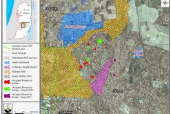
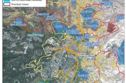
It should be noted that the Israel Lands Authority advanced a plan that includes the construction of a new residential neighborhood to the southeast of Ramot settlement, promoted by the National Committee for Housing-Preferential Zones. The program is intended to build a new neighborhood / settlement on 417 dunums of land in the area of the Mitzpe Naftuah green space, adjacent to the Ramot settlement and replace the existing “Mitzpe Naftuh” Green Space. According to the plan, a total of 1,435 settlement units, 203 protected settlement units (1638 in total), commercial areas, public institutions and open spaces to be built in the area. See Photo of the Original plan
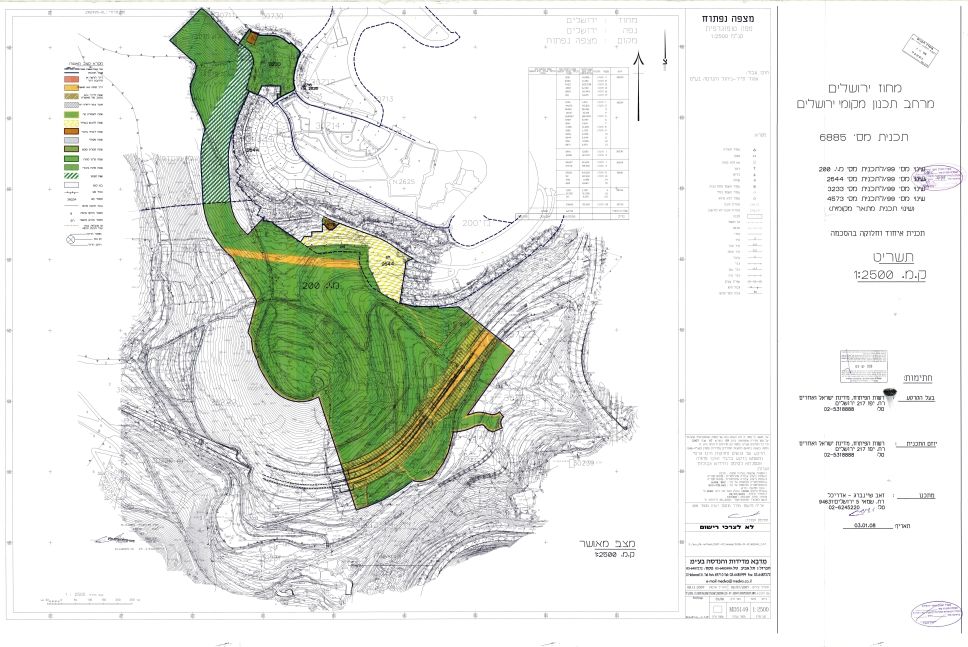
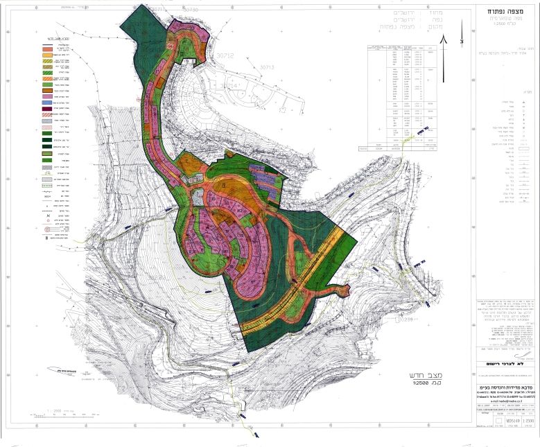
Photo 1-2: The Mitzpe Naftuh Plan as advanced by the National Committee for Housing-Preferential Zones
Map 1: The Mitzpe Naftuh Plan as advanced by the National Committee for Housing-Preferential Zones
Earlier on the 11th of November 2015, the Yedi’ot Ahranot news website reported that the National Committee for Housing-Preferential Zones in Jerusalem[1] approved the construction of 1638 new settlement units in the so-called “Mitzpe Naftuh” Green space near Ramot settlement in Jerusalem despite oppositions made by the Israeli Jerusalem Municipality and the Israeli Ministry of Environment and other green organization. For more information, click here: "Mordot Ramot"
A unique Green area to be replaced by a colonial neighborhood
It should be noted that in June, 2015 the Israeli ministry of Housing and construction gave a fast-track approval of the so-called “Mitzpe Naftuh” construction plan in Jerusalem city. The plan was labeled as “a priority area for the construction of new housing” and was sent to “the National Committee for Housing-Preferential Zones” that deals with approved priority sites and has the power to overrule any requirements of the approved plan.
Impact of the “Mitzpe Naftuh” plan on the Palestinian community
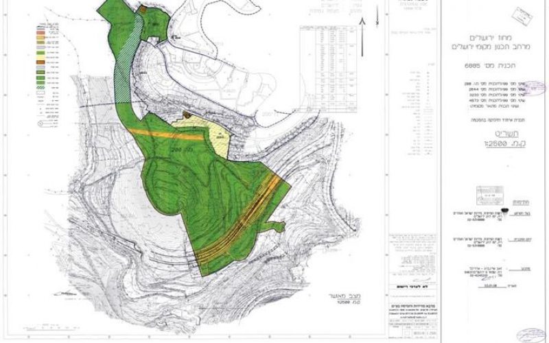
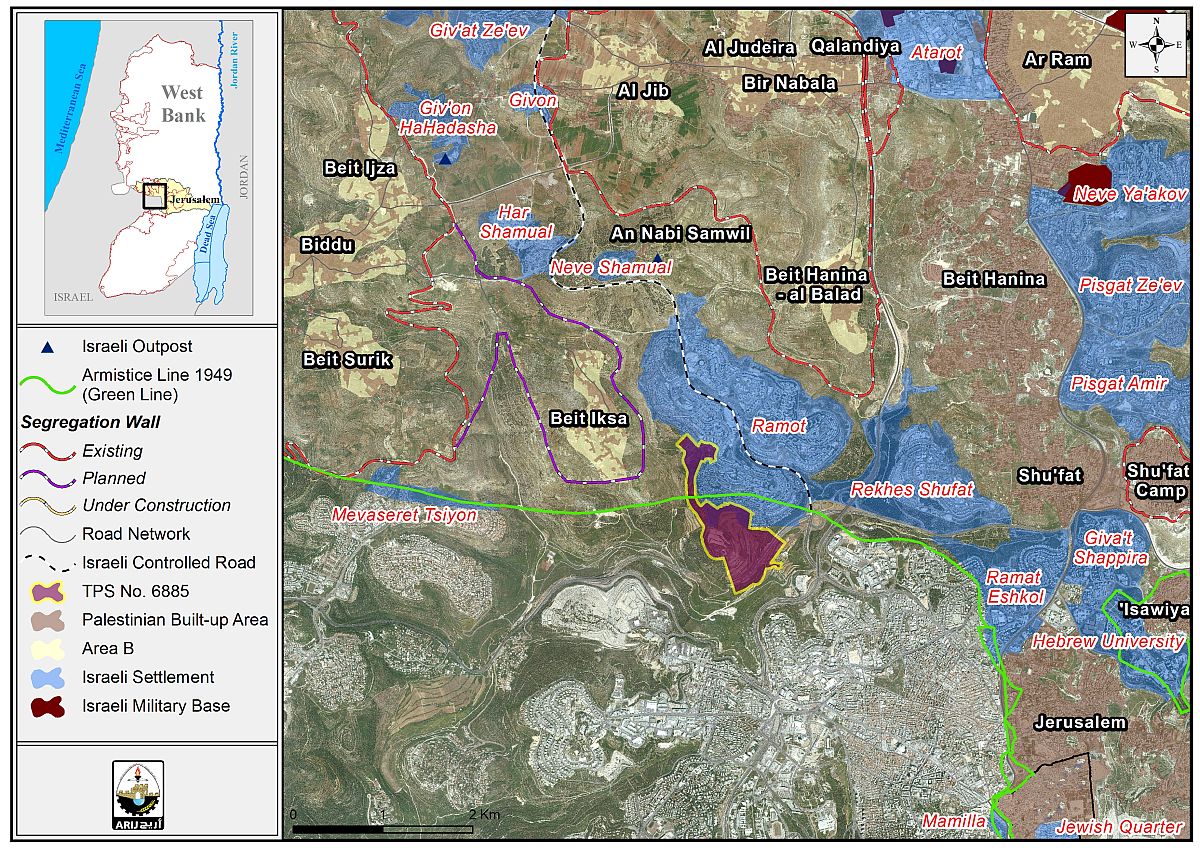
Analysis of TPS No. 6885 showed that the total area designated for the implementation of Mitzpe Naftuh plan is 709 dunums; out of which, 130 dunums to be implemented on lands of Beit Iksa village.
Moreover, during the years of the Israeli occupation, Beit Iksa village lost some of its land for several colonial projects, mainly for the establishment of three settlements on 1608 dunums of the village’s land. The settlemenets are Har Samuel, Ramot (Ramot Allon) and Neve Samuel. Today, the three settlements have a total population of more than 47,000 settlers. See Table 1
|
Table 1: Israeli settlements established on lands of Beit Iksa village – northwest Jerusalem city |
||||||
|
No. |
Governorate |
Settlement Name |
Establishment Date |
Population 2014-2015 |
Area (Dunums) |
Area confiscated form Beit Iksa village |
|
1 |
Jerusalem |
Ramot (Ramot Allon) |
1973 |
47026 |
3382 |
1541 |
|
2 |
Jerusalem |
Har Shamual |
1996 |
654 |
384 |
62 |
|
3 |
Jerusalem |
Neve Shamual |
1996 |
NA |
136 |
5 |
|
|
Total |
|
|
47680 |
3902 |
1608 |
|
|
ARIJ – GIS Database 2016 |
|||||
Additionally, the various maps and updates issued of the Israeli Segregation wall plan in the occupied West Bank showed that Beit Iksa village is set to lose more of its land for that purpose.
Maps of 2004 and 2005 showed that the wall has engulfed the village of Beit Iksa inside what became known to the Palestinians today as “the Western Segregation Zone and completely isolated it from the neighboring Palestinian villages.
On the 30th of June 2006, the so-called “Israeli Ministry of Defense" published on its website an updated map of the Segregation Wall route in the West Bank which illustrated changes on the Wall route in Beit Iksa village northwest of Jerusalem city along with changes in other areas in the West Bank; According to updated map, the Segregation Wall was re-routed to take the village's built-up area outside the Wall enclave (outside the western segregation Zone)[2].
Later on the 30th of April 2007, the Israeli Ministry of Defense published another revised route of the Segregation wall affirming the route of the wall of 2006 which sets to surround the village from three sides, east, west and south, setting the built up area of the village outside the Western Segregation Zone while isolating most of the village's land inside the western Segregation zone.
The village of Beit Iksa is currently isolated from its neighboring Palestinian villages located in the northwestern part of Jerusalem City, within the Giv’at Ze’ev settlement bloc according to the Wall of February 2005; and despite the changes that were depicted in the maps of June 2006 and April 2007; nothing has been implemented on the ground and villagers of Beit Iksa are still entrapped inside the wall and are not allowed to travel to Jerusalem City;
Moreover, the only entrance/exit from the village is through an Israeli checkpoint established on the northwestern side of the village where only villagers of Beit Iksa (those whose identification cards indicate Beit Iksa as their residence place) are allowed to enter or exit the village.
Related Cases, “Impairing the peace process” : Expediting expansion in Ramot settlement northwest of Jerusalem
[1] It is an entity which has the authority to approve most types of local outlines and plans in Jerusalem city
[2] The wall plan of 2002, February 2005 and June 2004 indicated that the village of Beit Iksa was totally isolated from the neighboring Palestinian villages of Beit Surik, Beit Ijza, Biddu and the remaining Palestinian villages located in the area.
Prepared by:
The Applied Research Institute – Jerusalem