- Violation: leveling agricultural lands
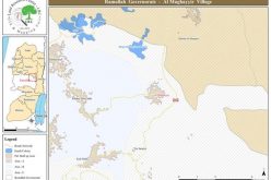
- Location: Al-Ju'beh village- Bethlehem
- Date: February 01, 2017
- Perpetrators: Israeli Occupation Forces
- Victims: citizen Khaled Masha'la
Details:
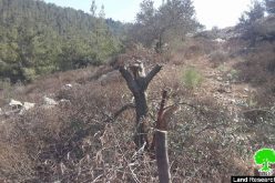
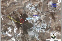
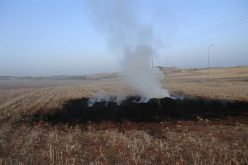
The dozers of Israeli Occupation Forces ravaged on February 01, 2017 an agricultural land founded nearby the military checkpoint at the eastern entrance of Al-Ju'beh village in Bethlehem governorate. Noteworthy, the targeted land of citizen Khaled Masha'la is 10 dunums in area and the occupation overlaid a layer of base-course on it as to open new parking lots to serve the colonists of Gosh Zion colonies bloc.
Shortly before the attack, Israeli Occupation Forces uprooted olive trees in the area in preparation to put hands on the land to initiate the new plan.
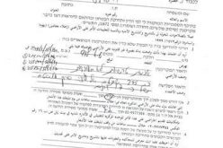
At time, citizen Masha'la filed an objection to Israeli courts to protect his lands from coming attacks but no positive results have been rendered in that regard.
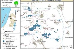
About Al-Ju'beh:
25km to the northwest of Hebron governorate , Al-Ju'beh village is edged by Nahhalin and Wad Fukin from the north, borders of 1967 from the west and Surif town from the south.
With a total land area of 7968 dunums, of which 153 dunums are the vilalge's built-up area, Al-Ju'beh is home for 876 people (2007 census).
The Israeli occupation confiscated 1322 dunums from the town to construct the following:
- Tsoref colony that was established in 1989 on 468 confiscated dunums.
- The bypass road number 367 that was opened on 514 confiscated dunums
- 340 dunums for the favor of the apartheid wall
According to the lands classifications of Oslo Accords, the lands of Al-Ju'beh are categorized as follows:
- 300 dunums are classified as area B
- 7655 dunums are classified as area C
Prepared by
The Land Research Center
LRC